|
|
|||||||||||||||||
| Point ID: 9071 | Downloads | Plots | Site Data | Code: 49107 |
|
|
|||||||||||||||||
| Download | |
|---|---|
| Site Descriptor Information | Site Time Series Data |
| Link to all available data | |
| View: | Time Series | All |
| Units: | m3/s |
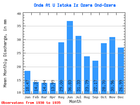
| Statistic | Jan | Feb | Mar | Apr | May | Jun | Jul | Aug | Sep | Oct | Nov | Dec | Annual |
|---|---|---|---|---|---|---|---|---|---|---|---|---|---|
| Mean | 18.47 | 14.49 | 14.04 | 13.99 | 28.99 | 36.83 | 31.33 | 23.78 | 22.17 | 28.69 | 30.96 | 26.99 | 296.51 |
| Standard Deviation | 0.73 | 1.16 | 1.20 | 1.41 | 6.32 | 6.63 | 4.14 | 5.31 | 8.60 | 20.27 | 19.68 | 10.93 | 73.62 |
| Min | 17.37 | 13.28 | 12.72 | 12.31 | 22.44 | 27.32 | 27.09 | 17.78 | 14.81 | 17.16 | 19.02 | 18.51 | 243.81 |
| Max | 19.13 | 16.02 | 15.41 | 15.11 | 37.22 | 45.73 | 37.22 | 29.88 | 37.83 | 69.48 | 70.55 | 48.60 | 420.80 |
| Coefficient of Variation | 0.04 | 0.08 | 0.09 | 0.10 | 0.22 | 0.18 | 0.13 | 0.22 | 0.39 | 0.71 | 0.64 | 0.41 | 0.25 |
 Return to R-Arctic Net Home Page