|
|
|||||||||||||||||
| Point ID: 9070 | Downloads | Plots | Site Data | Code: 49102 |
|
|
|||||||||||||||||
| Download | |
|---|---|
| Site Descriptor Information | Site Time Series Data |
| Link to all available data | |
| View: | Time Series | All |
| Units: | m3/s |
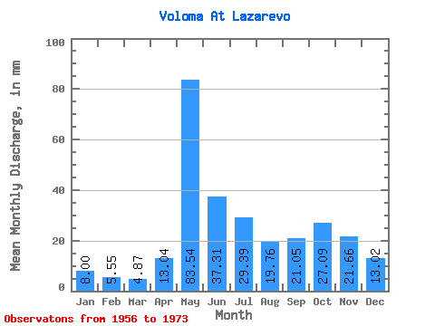
| Statistic | Jan | Feb | Mar | Apr | May | Jun | Jul | Aug | Sep | Oct | Nov | Dec | Annual |
|---|---|---|---|---|---|---|---|---|---|---|---|---|---|
| Mean | 8.00 | 5.60 | 4.87 | 13.04 | 83.53 | 37.31 | 29.39 | 19.75 | 21.05 | 27.09 | 21.66 | 13.02 | 281.67 |
| Standard Deviation | 2.28 | 1.08 | 0.88 | 12.89 | 28.14 | 14.80 | 35.12 | 15.34 | 14.21 | 13.06 | 9.38 | 5.52 | 107.78 |
| Min | 3.95 | 3.45 | 3.41 | 3.42 | 17.14 | 13.75 | 11.80 | 8.32 | 6.61 | 6.38 | 8.43 | 4.72 | 155.19 |
| Max | 13.26 | 7.27 | 6.18 | 57.48 | 125.70 | 63.12 | 152.66 | 70.50 | 58.72 | 54.84 | 44.08 | 25.14 | 603.27 |
| Coefficient of Variation | 0.28 | 0.19 | 0.18 | 0.99 | 0.34 | 0.40 | 1.20 | 0.78 | 0.68 | 0.48 | 0.43 | 0.42 | 0.38 |
 Return to R-Arctic Net Home Page