|
|
|||||||||||||||||
| Point ID: 9069 | Downloads | Plots | Site Data | Code: 49100 |
|
|
|||||||||||||||||
| Download | |
|---|---|
| Site Descriptor Information | Site Time Series Data |
| Link to all available data | |
| View: | Time Series | All |
| Units: | m3/s |
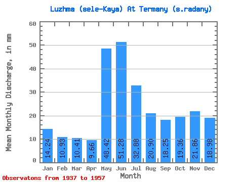
| Statistic | Jan | Feb | Mar | Apr | May | Jun | Jul | Aug | Sep | Oct | Nov | Dec | Annual |
|---|---|---|---|---|---|---|---|---|---|---|---|---|---|
| Mean | 14.24 | 11.02 | 10.40 | 9.66 | 48.41 | 51.28 | 32.88 | 20.89 | 18.25 | 19.35 | 21.86 | 18.97 | 281.43 |
| Standard Deviation | 4.31 | 3.13 | 2.63 | 2.88 | 23.00 | 20.93 | 13.77 | 7.12 | 9.40 | 7.93 | 10.72 | 7.93 | 55.13 |
| Min | 9.94 | 8.16 | 7.41 | 5.12 | 8.42 | 32.09 | 18.81 | 10.62 | 9.25 | 10.77 | 12.85 | 10.54 | 196.47 |
| Max | 26.40 | 20.11 | 16.99 | 13.58 | 77.38 | 93.99 | 65.93 | 31.10 | 39.72 | 31.64 | 46.85 | 38.39 | 366.78 |
| Coefficient of Variation | 0.30 | 0.28 | 0.25 | 0.30 | 0.47 | 0.41 | 0.42 | 0.34 | 0.52 | 0.41 | 0.49 | 0.42 | 0.20 |
 Return to R-Arctic Net Home Page