|
|
|||||||||||||||||
| Point ID: 9066 | Downloads | Plots | Site Data | Code: 49091 |
|
|
|||||||||||||||||
| Download | |
|---|---|
| Site Descriptor Information | Site Time Series Data |
| Link to all available data | |
| View: | Time Series | All |
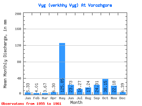
| Units: | m3/s |
| Statistic | Jan | Feb | Mar | Apr | May | Jun | Jul | Aug | Sep | Oct | Nov | Dec | Annual |
|---|---|---|---|---|---|---|---|---|---|---|---|---|---|
| Mean | 5.33 | 4.04 | 3.67 | 6.30 | 125.83 | 23.73 | 14.27 | 17.24 | 24.30 | 38.14 | 22.18 | 6.39 | 283.77 |
| Standard Deviation | 2.62 | 1.67 | 1.16 | 2.96 | 72.09 | 8.56 | 2.69 | 9.40 | 13.23 | 14.87 | 16.64 | 2.42 | 114.09 |
| Min | 1.99 | 1.77 | 1.98 | 2.26 | 30.21 | 11.17 | 11.00 | 10.37 | 10.21 | 19.30 | 11.17 | 2.82 | 163.97 |
| Max | 9.20 | 6.20 | 5.15 | 9.69 | 220.91 | 35.61 | 17.49 | 34.72 | 44.16 | 58.07 | 55.85 | 8.99 | 466.86 |
| Coefficient of Variation | 0.49 | 0.41 | 0.32 | 0.47 | 0.57 | 0.36 | 0.19 | 0.55 | 0.55 | 0.39 | 0.75 | 0.38 | 0.40 |
 Return to R-Arctic Net Home Page