|
|
|||||||||||||||||
| Point ID: 9065 | Downloads | Plots | Site Data | Code: 49087 |
|
|
|||||||||||||||||
| Download | |
|---|---|
| Site Descriptor Information | Site Time Series Data |
| Link to all available data | |
| View: | Time Series | All |
| Units: | m3/s |
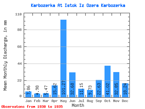
| Statistic | Jan | Feb | Mar | Apr | May | Jun | Jul | Aug | Sep | Oct | Nov | Dec | Annual |
|---|---|---|---|---|---|---|---|---|---|---|---|---|---|
| Mean | 7.86 | 5.02 | 5.47 | 15.62 | 101.26 | 32.68 | 11.15 | 9.72 | 22.63 | 41.01 | 32.84 | 18.24 | 297.49 |
| Standard Deviation | 1.27 | 1.62 | 1.60 | 7.20 | 34.17 | 22.12 | 3.56 | 11.78 | 21.65 | 23.23 | 10.32 | 6.82 | 98.71 |
| Min | 6.58 | 2.60 | 3.62 | 7.44 | 76.83 | 17.00 | 6.92 | 1.65 | 1.81 | 24.15 | 18.38 | 10.21 | 234.33 |
| Max | 9.88 | 6.90 | 7.13 | 26.56 | 155.85 | 70.64 | 16.02 | 29.96 | 58.64 | 84.18 | 43.55 | 27.44 | 467.58 |
| Coefficient of Variation | 0.16 | 0.32 | 0.29 | 0.46 | 0.34 | 0.68 | 0.32 | 1.21 | 0.96 | 0.57 | 0.31 | 0.37 | 0.33 |
 Return to R-Arctic Net Home Page