|
|
|||||||||||||||||
| Point ID: 9062 | Downloads | Plots | Site Data | Code: 49075 |
|
|
|||||||||||||||||
| Download | |
|---|---|
| Site Descriptor Information | Site Time Series Data |
| Link to all available data | |
| View: | Time Series | All |
| Units: | m3/s |
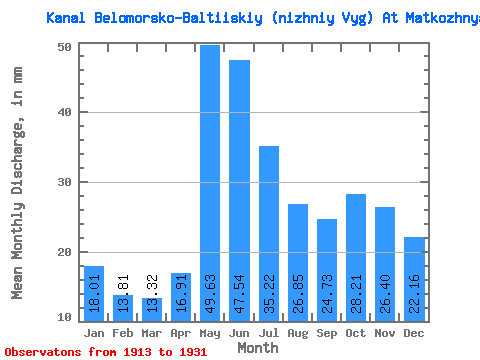
| Statistic | Jan | Feb | Mar | Apr | May | Jun | Jul | Aug | Sep | Oct | Nov | Dec | Annual |
|---|---|---|---|---|---|---|---|---|---|---|---|---|---|
| Mean | 18.01 | 13.92 | 13.32 | 16.91 | 49.62 | 47.54 | 35.22 | 26.85 | 24.73 | 28.21 | 26.40 | 22.15 | 323.06 |
| Standard Deviation | 6.04 | 4.25 | 3.59 | 7.88 | 10.92 | 10.81 | 7.81 | 7.71 | 8.74 | 8.94 | 10.65 | 7.81 | 48.41 |
| Min | 9.80 | 8.10 | 8.29 | 9.88 | 26.78 | 29.83 | 21.83 | 16.37 | 14.57 | 12.23 | 10.27 | 10.91 | 260.62 |
| Max | 31.23 | 24.95 | 22.84 | 37.56 | 67.71 | 66.12 | 46.49 | 49.62 | 45.29 | 41.63 | 46.36 | 37.69 | 431.72 |
| Coefficient of Variation | 0.34 | 0.30 | 0.27 | 0.47 | 0.22 | 0.23 | 0.22 | 0.29 | 0.35 | 0.32 | 0.40 | 0.35 | 0.15 |
 Return to R-Arctic Net Home Page