|
|
|||||||||||||||||
| Point ID: 9061 | Downloads | Plots | Site Data | Code: 49072 |
|
|
|||||||||||||||||
| Download | |
|---|---|
| Site Descriptor Information | Site Time Series Data |
| Link to all available data | |
| View: | Time Series | All |
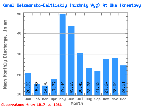
| Units: | m3/s |
| Statistic | Jan | Feb | Mar | Apr | May | Jun | Jul | Aug | Sep | Oct | Nov | Dec | Annual |
|---|---|---|---|---|---|---|---|---|---|---|---|---|---|
| Mean | 20.93 | 15.71 | 14.76 | 17.77 | 49.44 | 43.65 | 30.42 | 23.28 | 21.92 | 27.64 | 28.04 | 24.51 | 312.28 |
| Standard Deviation | 7.42 | 5.36 | 4.42 | 8.24 | 7.27 | 11.53 | 7.49 | 5.30 | 8.50 | 9.48 | 11.42 | 8.27 | 49.02 |
| Min | 10.70 | 9.23 | 9.21 | 9.38 | 39.66 | 28.02 | 20.97 | 15.50 | 13.68 | 11.74 | 10.75 | 11.74 | 258.19 |
| Max | 34.87 | 27.93 | 25.64 | 38.27 | 65.30 | 64.75 | 41.94 | 33.73 | 42.91 | 39.31 | 53.60 | 41.94 | 426.40 |
| Coefficient of Variation | 0.35 | 0.34 | 0.30 | 0.46 | 0.15 | 0.26 | 0.25 | 0.23 | 0.39 | 0.34 | 0.41 | 0.34 | 0.16 |
 Return to R-Arctic Net Home Page