|
|
|||||||||||||||||
| Point ID: 9059 | Downloads | Plots | Site Data | Code: 49059 |
|
|
|||||||||||||||||
| Download | |
|---|---|
| Site Descriptor Information | Site Time Series Data |
| Link to all available data | |
| View: | Time Series | All |
| Units: | m3/s |
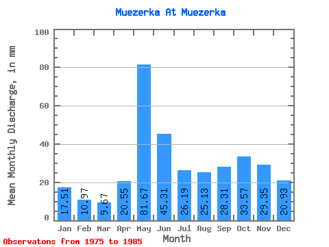
| Statistic | Jan | Feb | Mar | Apr | May | Jun | Jul | Aug | Sep | Oct | Nov | Dec | Annual |
|---|---|---|---|---|---|---|---|---|---|---|---|---|---|
| Mean | 17.51 | 11.07 | 9.67 | 20.55 | 81.66 | 45.31 | 26.19 | 25.12 | 28.31 | 33.57 | 29.35 | 20.93 | 348.05 |
| Standard Deviation | 7.06 | 2.69 | 1.65 | 15.78 | 30.87 | 23.09 | 17.81 | 18.54 | 16.92 | 15.29 | 10.54 | 6.85 | 103.91 |
| Min | 10.08 | 8.55 | 6.97 | 8.42 | 24.09 | 24.52 | 9.04 | 10.15 | 12.29 | 13.60 | 11.16 | 11.04 | 211.21 |
| Max | 32.44 | 15.85 | 12.01 | 50.70 | 126.31 | 92.86 | 69.02 | 71.78 | 66.34 | 52.18 | 45.03 | 34.79 | 532.30 |
| Coefficient of Variation | 0.40 | 0.24 | 0.17 | 0.77 | 0.38 | 0.51 | 0.68 | 0.74 | 0.60 | 0.46 | 0.36 | 0.33 | 0.30 |
 Return to R-Arctic Net Home Page