|
|
|||||||||||||||||
| Point ID: 9043 | Downloads | Plots | Site Data | Code: 71286 |
|
|
|||||||||||||||||
| Download | |
|---|---|
| Site Descriptor Information | Site Time Series Data |
| Link to all available data | |
| View: | Time Series | All |
| Units: | m3/s |
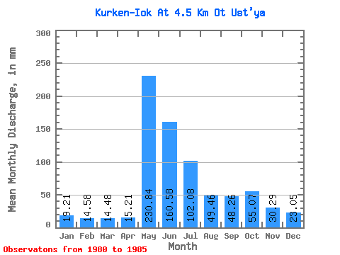
| Statistic | Jan | Feb | Mar | Apr | May | Jun | Jul | Aug | Sep | Oct | Nov | Dec | Annual |
|---|---|---|---|---|---|---|---|---|---|---|---|---|---|
| Mean | 19.20 | 14.70 | 14.48 | 15.21 | 230.80 | 160.59 | 102.06 | 49.46 | 48.26 | 55.06 | 30.29 | 23.05 | 763.01 |
| Standard Deviation | 2.87 | 1.96 | 1.87 | 4.10 | 74.18 | 53.64 | 39.91 | 7.75 | 16.55 | 24.46 | 4.03 | 2.80 | 27.38 |
| Min | 14.98 | 11.72 | 11.98 | 11.43 | 172.66 | 81.34 | 56.73 | 41.23 | 35.31 | 31.20 | 24.56 | 19.56 | 736.05 |
| Max | 22.55 | 16.70 | 16.21 | 22.17 | 336.51 | 194.40 | 153.63 | 58.85 | 71.96 | 81.75 | 35.81 | 27.13 | 795.77 |
| Coefficient of Variation | 0.15 | 0.13 | 0.13 | 0.27 | 0.32 | 0.33 | 0.39 | 0.16 | 0.34 | 0.44 | 0.13 | 0.12 | 0.04 |
 Return to R-Arctic Net Home Page