|
|
|||||||||||||||||
| Point ID: 9035 | Downloads | Plots | Site Data | Code: 71266 |
|
|
|||||||||||||||||
| Download | |
|---|---|
| Site Descriptor Information | Site Time Series Data |
| Link to all available data | |
| View: | Time Series | All |
| Units: | m3/s |
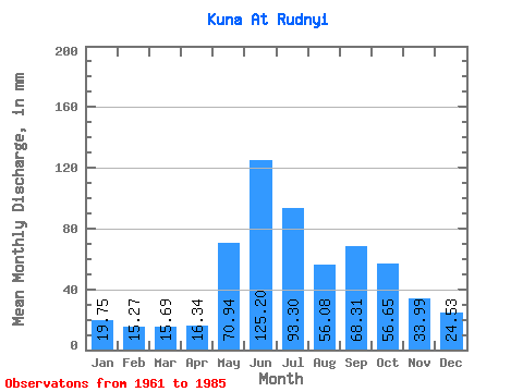
| Statistic | Jan | Feb | Mar | Apr | May | Jun | Jul | Aug | Sep | Oct | Nov | Dec | Annual |
|---|---|---|---|---|---|---|---|---|---|---|---|---|---|
| Mean | 19.75 | 15.41 | 15.69 | 16.35 | 70.93 | 125.20 | 93.28 | 56.07 | 68.31 | 56.65 | 33.99 | 24.53 | 594.63 |
| Standard Deviation | 4.55 | 3.66 | 2.44 | 4.92 | 35.24 | 26.41 | 39.40 | 17.76 | 22.63 | 17.84 | 10.52 | 5.06 | 88.40 |
| Min | 14.14 | 9.09 | 11.70 | 7.14 | 25.52 | 88.17 | 42.80 | 27.02 | 35.04 | 29.92 | 17.56 | 18.14 | 418.49 |
| Max | 33.69 | 27.26 | 21.83 | 28.58 | 145.29 | 202.95 | 203.40 | 101.31 | 124.66 | 92.67 | 56.70 | 35.97 | 727.38 |
| Coefficient of Variation | 0.23 | 0.24 | 0.16 | 0.30 | 0.50 | 0.21 | 0.42 | 0.32 | 0.33 | 0.32 | 0.31 | 0.21 | 0.15 |
 Return to R-Arctic Net Home Page