|
|
|||||||||||||||||
| Point ID: 9023 | Downloads | Plots | Site Data | Code: 71219 |
|
|
|||||||||||||||||
| Download | |
|---|---|
| Site Descriptor Information | Site Time Series Data |
| Link to all available data | |
| View: | Time Series | All |
| Units: | m3/s |
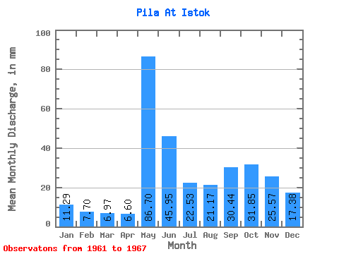
| Statistic | Jan | Feb | Mar | Apr | May | Jun | Jul | Aug | Sep | Oct | Nov | Dec | Annual |
|---|---|---|---|---|---|---|---|---|---|---|---|---|---|
| Mean | 11.29 | 7.77 | 6.96 | 6.60 | 86.68 | 45.95 | 22.53 | 21.17 | 30.45 | 31.85 | 25.56 | 17.38 | 318.29 |
| Standard Deviation | 1.80 | 1.17 | 1.59 | 3.40 | 25.00 | 14.82 | 6.78 | 9.85 | 14.09 | 16.22 | 6.44 | 5.44 | 34.92 |
| Min | 8.93 | 6.10 | 5.10 | 4.17 | 55.31 | 29.01 | 14.82 | 7.97 | 11.88 | 15.94 | 15.89 | 11.80 | 267.38 |
| Max | 13.87 | 9.15 | 9.56 | 12.50 | 123.06 | 63.72 | 29.01 | 32.84 | 42.89 | 54.20 | 31.78 | 27.26 | 364.29 |
| Coefficient of Variation | 0.16 | 0.15 | 0.23 | 0.51 | 0.29 | 0.32 | 0.30 | 0.47 | 0.46 | 0.51 | 0.25 | 0.31 | 0.11 |
 Return to R-Arctic Net Home Page