|
|
|||||||||||||||||
| Point ID: 9020 | Downloads | Plots | Site Data | Code: 71207 |
|
|
|||||||||||||||||
| Download | |
|---|---|
| Site Descriptor Information | Site Time Series Data |
| Link to all available data | |
| View: | Time Series | All |
| Units: | m3/s |
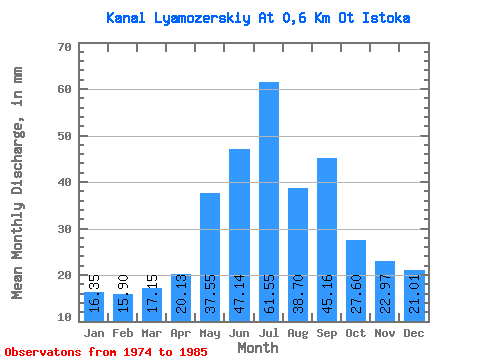
| Statistic | Jan | Feb | Mar | Apr | May | Jun | Jul | Aug | Sep | Oct | Nov | Dec | Annual |
|---|---|---|---|---|---|---|---|---|---|---|---|---|---|
| Mean | 16.35 | 16.03 | 17.14 | 20.14 | 37.54 | 47.15 | 61.54 | 38.69 | 45.16 | 27.60 | 22.98 | 21.01 | 378.53 |
| Standard Deviation | 12.21 | 14.13 | 13.62 | 11.44 | 28.18 | 32.53 | 39.98 | 10.58 | 32.56 | 17.57 | 16.43 | 14.05 | 88.92 |
| Min | 3.83 | 3.49 | 3.48 | 6.23 | 6.45 | 3.71 | 2.26 | 20.69 | 3.87 | 3.13 | 2.19 | 3.48 | 205.28 |
| Max | 43.47 | 53.71 | 46.78 | 42.08 | 100.86 | 94.09 | 130.77 | 57.92 | 91.06 | 59.30 | 55.38 | 47.99 | 481.08 |
| Coefficient of Variation | 0.75 | 0.88 | 0.80 | 0.57 | 0.75 | 0.69 | 0.65 | 0.27 | 0.72 | 0.64 | 0.71 | 0.67 | 0.23 |
 Return to R-Arctic Net Home Page