|
|
|||||||||||||||||
| Point ID: 9018 | Downloads | Plots | Site Data | Code: 71205 |
|
|
|||||||||||||||||
| Download | |
|---|---|
| Site Descriptor Information | Site Time Series Data |
| Link to all available data | |
| View: | Time Series | All |
| Units: | m3/s |
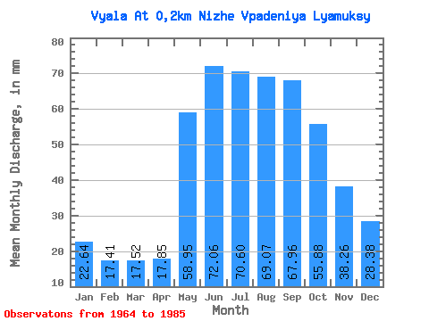
| Statistic | Jan | Feb | Mar | Apr | May | Jun | Jul | Aug | Sep | Oct | Nov | Dec | Annual |
|---|---|---|---|---|---|---|---|---|---|---|---|---|---|
| Mean | 22.63 | 17.55 | 17.52 | 17.85 | 58.94 | 72.05 | 70.59 | 69.06 | 67.96 | 55.87 | 38.26 | 28.38 | 543.21 |
| Standard Deviation | 9.78 | 7.23 | 7.15 | 7.01 | 25.08 | 17.84 | 18.93 | 16.94 | 13.99 | 17.12 | 13.70 | 13.70 | 77.10 |
| Min | 11.58 | 7.69 | 8.55 | 6.91 | 31.26 | 44.10 | 22.34 | 32.53 | 42.30 | 20.99 | 20.82 | 11.24 | 414.20 |
| Max | 45.94 | 37.43 | 36.49 | 31.89 | 134.09 | 100.50 | 93.75 | 99.72 | 97.25 | 82.17 | 66.52 | 70.59 | 674.30 |
| Coefficient of Variation | 0.43 | 0.41 | 0.41 | 0.39 | 0.42 | 0.25 | 0.27 | 0.24 | 0.21 | 0.31 | 0.36 | 0.48 | 0.14 |
 Return to R-Arctic Net Home Page