|
|
|||||||||||||||||
| Point ID: 9016 | Downloads | Plots | Site Data | Code: 71202 |
|
|
|||||||||||||||||
| Download | |
|---|---|
| Site Descriptor Information | Site Time Series Data |
| Link to all available data | |
| View: | Time Series | All |
| Units: | m3/s |
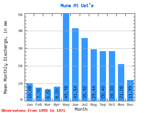
| Statistic | Jan | Feb | Mar | Apr | May | Jun | Jul | Aug | Sep | Oct | Nov | Dec | Annual |
|---|---|---|---|---|---|---|---|---|---|---|---|---|---|
| Mean | 10.07 | 7.77 | 6.62 | 8.20 | 49.78 | 41.54 | 35.91 | 29.44 | 28.40 | 28.32 | 21.08 | 11.99 | 276.77 |
| Standard Deviation | 3.44 | 2.63 | 2.22 | 5.72 | 21.40 | 20.09 | 18.38 | 10.30 | 11.08 | 10.10 | 8.89 | 4.18 | 64.94 |
| Min | 4.05 | 2.05 | 3.12 | 1.60 | 18.09 | 21.37 | 6.49 | 12.87 | 9.23 | 9.02 | 6.02 | 5.92 | 135.05 |
| Max | 18.12 | 11.83 | 12.96 | 22.53 | 102.39 | 103.31 | 74.15 | 51.88 | 46.27 | 44.54 | 40.75 | 21.86 | 407.39 |
| Coefficient of Variation | 0.34 | 0.34 | 0.34 | 0.70 | 0.43 | 0.48 | 0.51 | 0.35 | 0.39 | 0.36 | 0.42 | 0.35 | 0.23 |
 Return to R-Arctic Net Home Page