|
|
|||||||||||||||||
| Point ID: 901 | Downloads | Plots | Site Data | Code: 07FD007 |
|
|
|||||||||||||||||
| Download | |
|---|---|
| Site Descriptor Information | Site Time Series Data |
| Link to all available data | |
| View: | Time Series | All |
| Units: | m3/s |
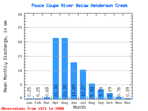
| Statistic | Jan | Feb | Mar | Apr | May | Jun | Jul | Aug | Sep | Oct | Nov | Dec | Annual |
|---|---|---|---|---|---|---|---|---|---|---|---|---|---|
| Mean | 0.25 | 0.25 | 0.68 | 21.34 | 21.32 | 12.89 | 10.27 | 5.43 | 3.38 | 2.09 | 0.76 | 0.39 | 78.42 |
| Standard Deviation | 0.22 | 0.27 | 0.72 | 22.40 | 19.67 | 13.26 | 16.68 | 12.84 | 8.58 | 3.76 | 0.89 | 0.31 | 51.94 |
| Min | 0.01 | 0.01 | 0.02 | 0.71 | 1.06 | 0.64 | 0.05 | 0.02 | 0.05 | 0.10 | 0.05 | 0.01 | 12.49 |
| Max | 0.74 | 1.37 | 3.12 | 87.58 | 74.98 | 47.38 | 82.69 | 61.27 | 41.65 | 18.89 | 3.87 | 1.16 | 201.63 |
| Coefficient of Variation | 0.88 | 1.06 | 1.05 | 1.05 | 0.92 | 1.03 | 1.62 | 2.37 | 2.54 | 1.79 | 1.17 | 0.78 | 0.66 |
 Return to R-Arctic Net Home Page