|
|
|||||||||||||||||
| Point ID: 9005 | Downloads | Plots | Site Data | Code: 71162 |
|
|
|||||||||||||||||
| Download | |
|---|---|
| Site Descriptor Information | Site Time Series Data |
| Link to all available data | |
| View: | Time Series | All |
| Units: | m3/s |
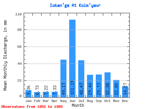
| Statistic | Jan | Feb | Mar | Apr | May | Jun | Jul | Aug | Sep | Oct | Nov | Dec | Annual |
|---|---|---|---|---|---|---|---|---|---|---|---|---|---|
| Mean | 9.36 | 6.79 | 7.22 | 7.32 | 49.17 | 101.19 | 48.46 | 29.39 | 29.78 | 32.38 | 22.80 | 14.26 | 365.69 |
| Standard Deviation | 3.69 | 3.29 | 4.13 | 4.04 | 39.04 | 29.27 | 20.61 | 14.35 | 13.07 | 10.76 | 9.75 | 4.91 | 67.47 |
| Min | 4.24 | 1.75 | 1.17 | 0.73 | 0.14 | 23.01 | 13.80 | 9.91 | 11.37 | 13.87 | 12.10 | 9.09 | 259.98 |
| Max | 19.13 | 15.56 | 16.81 | 14.48 | 125.70 | 148.78 | 107.94 | 70.37 | 60.57 | 52.40 | 57.99 | 30.00 | 468.57 |
| Coefficient of Variation | 0.40 | 0.48 | 0.57 | 0.55 | 0.79 | 0.29 | 0.42 | 0.49 | 0.44 | 0.33 | 0.43 | 0.34 | 0.18 |
 Return to R-Arctic Net Home Page