|
|
|||||||||||||||||
| Point ID: 9004 | Downloads | Plots | Site Data | Code: 71161 |
|
|
|||||||||||||||||
| Download | |
|---|---|
| Site Descriptor Information | Site Time Series Data |
| Link to all available data | |
| View: | Time Series | All |
| Units: | m3/s |
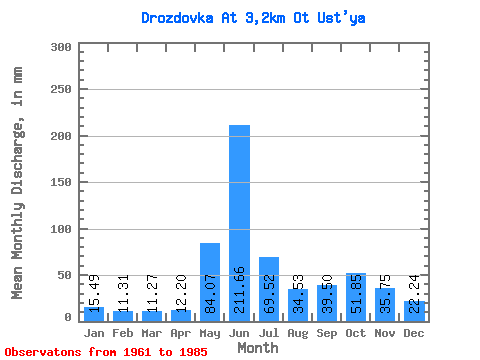
| Statistic | Jan | Feb | Mar | Apr | May | Jun | Jul | Aug | Sep | Oct | Nov | Dec | Annual |
|---|---|---|---|---|---|---|---|---|---|---|---|---|---|
| Mean | 15.49 | 11.40 | 11.27 | 12.21 | 84.06 | 211.66 | 69.51 | 34.52 | 39.50 | 51.84 | 35.74 | 22.24 | 603.44 |
| Standard Deviation | 3.13 | 2.82 | 3.40 | 4.78 | 68.42 | 58.46 | 45.68 | 20.25 | 19.39 | 28.45 | 14.71 | 5.02 | 91.80 |
| Min | 9.85 | 5.74 | 6.56 | 5.08 | 9.26 | 120.07 | 25.27 | 8.99 | 17.28 | 22.18 | 20.27 | 13.06 | 462.06 |
| Max | 20.94 | 16.15 | 17.52 | 23.44 | 227.76 | 340.52 | 212.66 | 80.73 | 75.60 | 146.37 | 78.78 | 37.74 | 740.01 |
| Coefficient of Variation | 0.20 | 0.25 | 0.30 | 0.39 | 0.81 | 0.28 | 0.66 | 0.59 | 0.49 | 0.55 | 0.41 | 0.23 | 0.15 |
 Return to R-Arctic Net Home Page