|
|
|||||||||||||||||
| Point ID: 9000 | Downloads | Plots | Site Data | Code: 71150 |
|
|
|||||||||||||||||
| Download | |
|---|---|
| Site Descriptor Information | Site Time Series Data |
| Link to all available data | |
| View: | Time Series | All |
| Units: | m3/s |
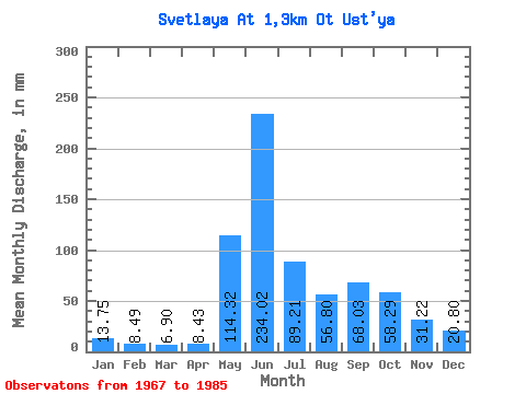
| Statistic | Jan | Feb | Mar | Apr | May | Jun | Jul | Aug | Sep | Oct | Nov | Dec | Annual |
|---|---|---|---|---|---|---|---|---|---|---|---|---|---|
| Mean | 13.74 | 8.55 | 6.89 | 8.43 | 114.31 | 234.03 | 89.21 | 56.78 | 68.03 | 58.29 | 31.21 | 20.79 | 719.87 |
| Standard Deviation | 3.45 | 2.29 | 1.77 | 7.10 | 85.50 | 75.91 | 71.07 | 20.04 | 24.73 | 20.37 | 7.80 | 4.72 | 112.48 |
| Min | 10.52 | 4.96 | 4.35 | 4.21 | 9.07 | 109.58 | 37.74 | 26.13 | 40.04 | 38.83 | 24.23 | 16.33 | 566.98 |
| Max | 21.05 | 11.57 | 9.80 | 25.64 | 288.12 | 325.23 | 282.31 | 91.81 | 120.47 | 111.04 | 42.50 | 27.96 | 833.55 |
| Coefficient of Variation | 0.25 | 0.27 | 0.26 | 0.84 | 0.75 | 0.32 | 0.80 | 0.35 | 0.36 | 0.35 | 0.25 | 0.23 | 0.16 |
 Return to R-Arctic Net Home Page