|
|
|||||||||||||||||
| Point ID: 8998 | Downloads | Plots | Site Data | Code: 71148 |
|
|
|||||||||||||||||
| Download | |
|---|---|
| Site Descriptor Information | Site Time Series Data |
| Link to all available data | |
| View: | Time Series | All |
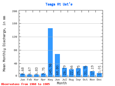
| Units: | m3/s |
| Statistic | Jan | Feb | Mar | Apr | May | Jun | Jul | Aug | Sep | Oct | Nov | Dec | Annual |
|---|---|---|---|---|---|---|---|---|---|---|---|---|---|
| Mean | 8.68 | 6.72 | 6.83 | 9.75 | 145.96 | 68.80 | 26.79 | 22.66 | 25.75 | 31.75 | 17.19 | 11.01 | 353.57 |
| Standard Deviation | 1.55 | 1.38 | 1.33 | 5.05 | 40.68 | 42.41 | 12.75 | 7.90 | 8.16 | 10.42 | 2.81 | 1.56 | 56.27 |
| Min | 7.66 | 5.44 | 4.96 | 5.78 | 100.36 | 30.68 | 14.05 | 11.99 | 13.09 | 19.49 | 14.57 | 9.14 | 313.79 |
| Max | 10.46 | 8.18 | 8.08 | 17.08 | 178.53 | 187.12 | 57.57 | 36.18 | 39.98 | 43.00 | 21.17 | 12.68 | 393.36 |
| Coefficient of Variation | 0.18 | 0.20 | 0.19 | 0.52 | 0.28 | 0.62 | 0.48 | 0.35 | 0.32 | 0.33 | 0.16 | 0.14 | 0.16 |
 Return to R-Arctic Net Home Page