|
|
|||||||||||||||||
| Point ID: 8995 | Downloads | Plots | Site Data | Code: 71143 |
|
|
|||||||||||||||||
| Download | |
|---|---|
| Site Descriptor Information | Site Time Series Data |
| Link to all available data | |
| View: | Time Series | All |
| Units: | m3/s |
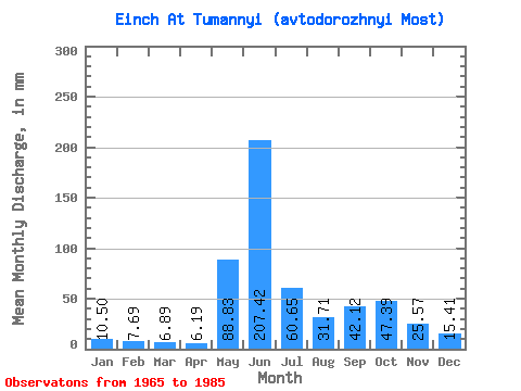
| Statistic | Jan | Feb | Mar | Apr | May | Jun | Jul | Aug | Sep | Oct | Nov | Dec | Annual |
|---|---|---|---|---|---|---|---|---|---|---|---|---|---|
| Mean | 10.49 | 7.75 | 6.88 | 6.20 | 88.82 | 207.42 | 60.63 | 31.70 | 42.12 | 47.38 | 25.57 | 15.40 | 539.75 |
| Standard Deviation | 2.15 | 2.05 | 2.16 | 1.60 | 76.52 | 57.96 | 41.16 | 15.47 | 15.16 | 17.95 | 12.05 | 3.73 | 91.70 |
| Min | 7.22 | 4.99 | 4.09 | 2.94 | 7.22 | 95.10 | 16.09 | 10.00 | 16.24 | 20.95 | 13.97 | 10.26 | 361.80 |
| Max | 14.87 | 12.68 | 13.48 | 8.92 | 278.23 | 291.18 | 155.64 | 63.73 | 78.77 | 83.73 | 64.55 | 25.65 | 709.50 |
| Coefficient of Variation | 0.20 | 0.26 | 0.31 | 0.26 | 0.86 | 0.28 | 0.68 | 0.49 | 0.36 | 0.38 | 0.47 | 0.24 | 0.17 |
 Return to R-Arctic Net Home Page