|
|
|||||||||||||||||
| Point ID: 8986 | Downloads | Plots | Site Data | Code: 71113 |
|
|
|||||||||||||||||
| Download | |
|---|---|
| Site Descriptor Information | Site Time Series Data |
| Link to all available data | |
| View: | Time Series | All |
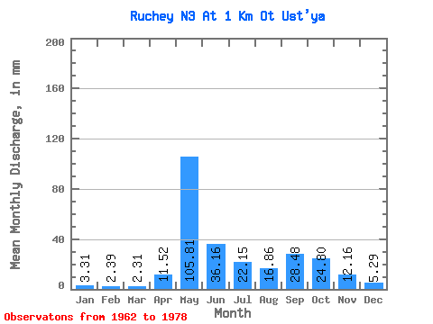
| Units: | m3/s |
| Statistic | Jan | Feb | Mar | Apr | May | Jun | Jul | Aug | Sep | Oct | Nov | Dec | Annual |
|---|---|---|---|---|---|---|---|---|---|---|---|---|---|
| Mean | 3.35 | 2.53 | 2.27 | 11.42 | 105.67 | 36.02 | 21.99 | 16.70 | 28.54 | 24.91 | 12.27 | 5.38 | 285.94 |
| Standard Deviation | 1.77 | 1.86 | 2.02 | 10.35 | 41.21 | 15.33 | 11.52 | 8.12 | 28.87 | 12.92 | 9.07 | 1.76 | 69.04 |
| Min | 0.99 | 0.00 | 0.00 | 0.64 | 29.43 | 15.04 | 11.24 | 5.62 | 7.36 | 7.94 | 5.12 | 2.31 | 156.18 |
| Max | 7.60 | 6.03 | 5.29 | 32.32 | 157.04 | 67.20 | 50.91 | 28.43 | 129.60 | 58.19 | 41.28 | 9.26 | 410.74 |
| Coefficient of Variation | 0.53 | 0.73 | 0.89 | 0.91 | 0.39 | 0.43 | 0.52 | 0.49 | 1.01 | 0.52 | 0.74 | 0.33 | 0.24 |
 Return to R-Arctic Net Home Page