|
|
|||||||||||||||||
| Point ID: 8985 | Downloads | Plots | Site Data | Code: 71112 |
|
|
|||||||||||||||||
| Download | |
|---|---|
| Site Descriptor Information | Site Time Series Data |
| Link to all available data | |
| View: | Time Series | All |
| Units: | m3/s |
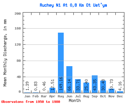
| Statistic | Jan | Feb | Mar | Apr | May | Jun | Jul | Aug | Sep | Oct | Nov | Dec | Annual |
|---|---|---|---|---|---|---|---|---|---|---|---|---|---|
| Mean | 1.24 | 0.68 | 0.60 | 12.66 | 149.25 | 66.36 | 33.84 | 25.51 | 43.24 | 30.44 | 10.78 | 4.16 | 378.36 |
| Standard Deviation | 1.82 | 1.16 | 1.07 | 19.66 | 72.18 | 43.11 | 23.84 | 15.27 | 30.52 | 19.59 | 13.26 | 9.97 | 131.44 |
| Min | 0.00 | 0.00 | 0.00 | 0.00 | 34.17 | 8.49 | 6.46 | 6.93 | 8.04 | 4.62 | 0.00 | 0.00 | 197.70 |
| Max | 6.93 | 4.63 | 4.16 | 62.57 | 320.44 | 165.35 | 100.19 | 60.02 | 172.95 | 73.41 | 61.23 | 50.79 | 676.54 |
| Coefficient of Variation | 1.47 | 1.72 | 1.79 | 1.55 | 0.48 | 0.65 | 0.70 | 0.60 | 0.71 | 0.64 | 1.23 | 2.40 | 0.35 |
 Return to R-Arctic Net Home Page