|
|
|||||||||||||||||
| Point ID: 8982 | Downloads | Plots | Site Data | Code: 71107 |
|
|
|||||||||||||||||
| Download | |
|---|---|
| Site Descriptor Information | Site Time Series Data |
| Link to all available data | |
| View: | Time Series | All |
| Units: | m3/s |
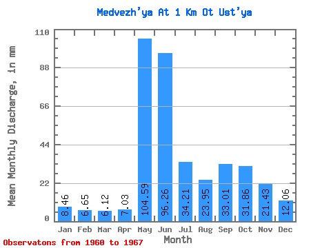
| Statistic | Jan | Feb | Mar | Apr | May | Jun | Jul | Aug | Sep | Oct | Nov | Dec | Annual |
|---|---|---|---|---|---|---|---|---|---|---|---|---|---|
| Mean | 8.46 | 6.71 | 6.12 | 7.03 | 104.57 | 96.26 | 34.20 | 23.94 | 33.01 | 31.86 | 21.43 | 12.06 | 414.48 |
| Standard Deviation | 2.21 | 0.89 | 0.86 | 2.23 | 50.01 | 61.33 | 13.73 | 15.38 | 12.92 | 14.96 | 7.28 | 3.76 | 32.97 |
| Min | 5.90 | 5.42 | 5.02 | 4.74 | 39.52 | 38.66 | 12.36 | 6.58 | 10.70 | 9.62 | 5.27 | 4.47 | 380.58 |
| Max | 12.95 | 8.30 | 7.46 | 10.94 | 164.90 | 193.89 | 55.67 | 49.34 | 53.88 | 50.19 | 26.37 | 15.94 | 456.00 |
| Coefficient of Variation | 0.26 | 0.13 | 0.14 | 0.32 | 0.48 | 0.64 | 0.40 | 0.64 | 0.39 | 0.47 | 0.34 | 0.31 | 0.08 |
 Return to R-Arctic Net Home Page