|
|
|||||||||||||||||
| Point ID: 8981 | Downloads | Plots | Site Data | Code: 71106 |
|
|
|||||||||||||||||
| Download | |
|---|---|
| Site Descriptor Information | Site Time Series Data |
| Link to all available data | |
| View: | Time Series | All |
| Units: | m3/s |
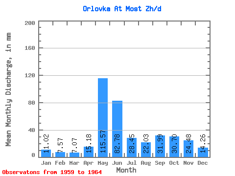
| Statistic | Jan | Feb | Mar | Apr | May | Jun | Jul | Aug | Sep | Oct | Nov | Dec | Annual |
|---|---|---|---|---|---|---|---|---|---|---|---|---|---|
| Mean | 11.02 | 7.63 | 7.07 | 15.18 | 115.55 | 82.78 | 28.45 | 22.03 | 31.98 | 30.69 | 24.48 | 14.26 | 383.93 |
| Standard Deviation | 3.33 | 1.54 | 0.81 | 14.89 | 61.00 | 72.42 | 11.10 | 10.25 | 8.56 | 14.63 | 8.89 | 4.55 | 103.24 |
| Min | 6.60 | 5.77 | 6.27 | 6.00 | 48.81 | 29.50 | 12.07 | 10.29 | 21.77 | 15.24 | 9.51 | 7.98 | 234.30 |
| Max | 14.45 | 9.26 | 8.24 | 41.50 | 182.05 | 222.81 | 35.82 | 35.29 | 41.94 | 50.39 | 32.24 | 19.20 | 455.59 |
| Coefficient of Variation | 0.30 | 0.20 | 0.12 | 0.98 | 0.53 | 0.88 | 0.39 | 0.47 | 0.27 | 0.48 | 0.36 | 0.32 | 0.27 |
 Return to R-Arctic Net Home Page