|
|
|||||||||||||||||
| Point ID: 8975 | Downloads | Plots | Site Data | Code: 71092 |
|
|
|||||||||||||||||
| Download | |
|---|---|
| Site Descriptor Information | Site Time Series Data |
| Link to all available data | |
| View: | Time Series | All |
| Units: | m3/s |
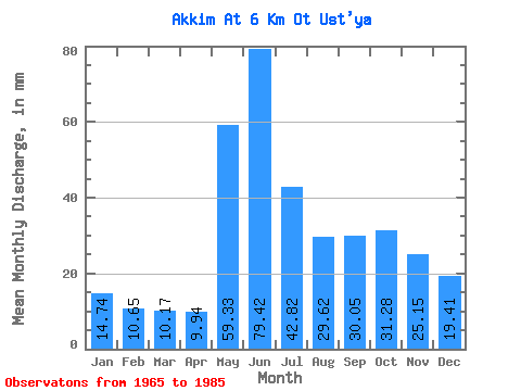
| Statistic | Jan | Feb | Mar | Apr | May | Jun | Jul | Aug | Sep | Oct | Nov | Dec | Annual |
|---|---|---|---|---|---|---|---|---|---|---|---|---|---|
| Mean | 14.74 | 10.74 | 10.17 | 9.95 | 59.32 | 79.42 | 42.81 | 29.61 | 30.05 | 31.28 | 25.15 | 19.41 | 356.89 |
| Standard Deviation | 2.31 | 1.52 | 1.34 | 2.22 | 30.67 | 25.25 | 22.28 | 14.02 | 14.29 | 9.94 | 9.00 | 4.24 | 78.33 |
| Min | 9.79 | 7.48 | 7.25 | 7.39 | 18.80 | 37.21 | 19.89 | 14.46 | 13.42 | 14.69 | 16.05 | 12.74 | 251.81 |
| Max | 21.42 | 14.27 | 13.81 | 18.14 | 124.72 | 136.82 | 110.18 | 70.01 | 67.76 | 47.06 | 56.47 | 34.62 | 517.81 |
| Coefficient of Variation | 0.16 | 0.14 | 0.13 | 0.22 | 0.52 | 0.32 | 0.52 | 0.47 | 0.48 | 0.32 | 0.36 | 0.22 | 0.22 |
 Return to R-Arctic Net Home Page