|
|
|||||||||||||||||
| Point ID: 897 | Downloads | Plots | Site Data | Code: 07FD001 |
|
|
|||||||||||||||||
| Download | |
|---|---|
| Site Descriptor Information | Site Time Series Data |
| Link to all available data | |
| View: | Time Series | All |
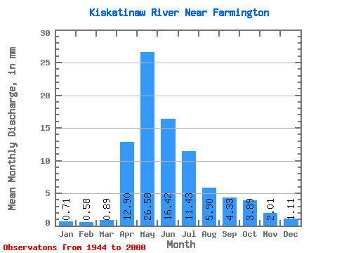
| Units: | m3/s |
| Statistic | Jan | Feb | Mar | Apr | May | Jun | Jul | Aug | Sep | Oct | Nov | Dec | Annual |
|---|---|---|---|---|---|---|---|---|---|---|---|---|---|
| Mean | 0.71 | 0.58 | 0.89 | 12.90 | 26.58 | 16.42 | 11.43 | 5.90 | 4.33 | 3.89 | 2.01 | 1.11 | 92.61 |
| Standard Deviation | 0.41 | 0.39 | 0.77 | 12.30 | 23.05 | 15.46 | 12.61 | 9.33 | 6.25 | 4.83 | 1.52 | 0.67 | 48.48 |
| Min | 0.10 | 0.09 | 0.02 | 0.03 | 2.15 | 1.15 | 0.23 | 0.04 | 0.08 | 0.16 | 0.08 | 0.08 | 22.45 |
| Max | 1.67 | 1.70 | 4.44 | 59.90 | 125.27 | 75.51 | 50.26 | 45.53 | 29.33 | 23.70 | 7.33 | 3.30 | 253.39 |
| Coefficient of Variation | 0.57 | 0.67 | 0.87 | 0.95 | 0.87 | 0.94 | 1.10 | 1.58 | 1.44 | 1.24 | 0.76 | 0.60 | 0.52 |
 Return to R-Arctic Net Home Page