|
|
|||||||||||||||||
| Point ID: 8954 | Downloads | Plots | Site Data | Code: 71031 |
|
|
|||||||||||||||||
| Download | |
|---|---|
| Site Descriptor Information | Site Time Series Data |
| Link to all available data | |
| View: | Time Series | All |
| Units: | m3/s |
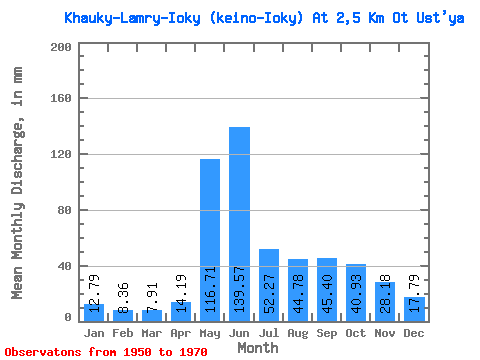
| Statistic | Jan | Feb | Mar | Apr | May | Jun | Jul | Aug | Sep | Oct | Nov | Dec | Annual |
|---|---|---|---|---|---|---|---|---|---|---|---|---|---|
| Mean | 12.77 | 8.43 | 7.92 | 14.20 | 116.71 | 139.56 | 52.25 | 44.77 | 45.40 | 40.92 | 28.18 | 17.81 | 534.06 |
| Standard Deviation | 4.49 | 3.45 | 3.95 | 13.00 | 60.93 | 57.53 | 23.84 | 22.53 | 18.44 | 13.86 | 11.34 | 5.95 | 86.86 |
| Min | 4.21 | 1.94 | 1.98 | 1.06 | 35.88 | 48.82 | 13.52 | 17.16 | 24.16 | 24.96 | 12.08 | 7.80 | 354.92 |
| Max | 22.88 | 14.21 | 14.56 | 53.85 | 293.80 | 239.07 | 96.72 | 105.56 | 89.08 | 76.96 | 56.37 | 29.64 | 646.52 |
| Coefficient of Variation | 0.35 | 0.41 | 0.50 | 0.92 | 0.52 | 0.41 | 0.46 | 0.50 | 0.41 | 0.34 | 0.40 | 0.33 | 0.16 |
 Return to R-Arctic Net Home Page