|
|
|||||||||||||||||
| Point ID: 8949 | Downloads | Plots | Site Data | Code: 71025 |
|
|
|||||||||||||||||
| Download | |
|---|---|
| Site Descriptor Information | Site Time Series Data |
| Link to all available data | |
| View: | Time Series | All |
| Units: | m3/s |
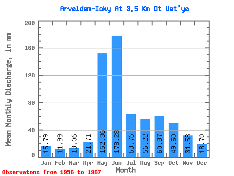
| Statistic | Jan | Feb | Mar | Apr | May | Jun | Jul | Aug | Sep | Oct | Nov | Dec | Annual |
|---|---|---|---|---|---|---|---|---|---|---|---|---|---|
| Mean | 15.78 | 12.09 | 13.06 | 21.71 | 152.34 | 178.28 | 63.76 | 56.22 | 60.87 | 49.50 | 31.58 | 18.71 | 673.26 |
| Standard Deviation | 3.73 | 2.89 | 3.31 | 12.99 | 83.60 | 73.61 | 22.61 | 31.71 | 27.66 | 21.34 | 9.02 | 4.29 | 113.75 |
| Min | 8.22 | 6.42 | 7.99 | 7.96 | 53.09 | 66.85 | 20.91 | 22.55 | 28.88 | 29.36 | 14.55 | 10.34 | 471.32 |
| Max | 22.08 | 15.20 | 17.62 | 50.02 | 328.88 | 268.30 | 94.20 | 121.22 | 124.37 | 102.89 | 45.25 | 28.19 | 810.23 |
| Coefficient of Variation | 0.24 | 0.24 | 0.25 | 0.60 | 0.55 | 0.41 | 0.35 | 0.56 | 0.45 | 0.43 | 0.29 | 0.23 | 0.17 |
 Return to R-Arctic Net Home Page