|
|
|||||||||||||||||
| Point ID: 8946 | Downloads | Plots | Site Data | Code: 71016 |
|
|
|||||||||||||||||
| Download | |
|---|---|
| Site Descriptor Information | Site Time Series Data |
| Link to all available data | |
| View: | Time Series | All |
| Units: | m3/s |
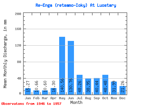
| Statistic | Jan | Feb | Mar | Apr | May | Jun | Jul | Aug | Sep | Oct | Nov | Dec | Annual |
|---|---|---|---|---|---|---|---|---|---|---|---|---|---|
| Mean | 15.26 | 10.75 | 10.59 | 16.30 | 140.54 | 130.75 | 48.25 | 38.94 | 40.44 | 48.47 | 31.99 | 21.26 | 543.34 |
| Standard Deviation | 3.02 | 2.05 | 1.55 | 6.74 | 58.12 | 46.21 | 19.66 | 17.24 | 14.71 | 15.44 | 11.94 | 5.86 | 105.53 |
| Min | 10.92 | 7.91 | 8.47 | 7.78 | 54.39 | 55.26 | 23.87 | 13.47 | 19.73 | 29.27 | 17.54 | 13.83 | 334.38 |
| Max | 21.18 | 15.61 | 13.85 | 28.93 | 240.81 | 204.95 | 87.61 | 69.55 | 67.11 | 77.23 | 56.26 | 30.31 | 686.98 |
| Coefficient of Variation | 0.20 | 0.19 | 0.15 | 0.41 | 0.41 | 0.35 | 0.41 | 0.44 | 0.36 | 0.32 | 0.37 | 0.28 | 0.19 |
 Return to R-Arctic Net Home Page