|
|
|||||||||||||||||
| Point ID: 8945 | Downloads | Plots | Site Data | Code: 71012 |
|
|
|||||||||||||||||
| Download | |
|---|---|
| Site Descriptor Information | Site Time Series Data |
| Link to all available data | |
| View: | Time Series | All |
| Units: | m3/s |
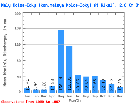
| Statistic | Jan | Feb | Mar | Apr | May | Jun | Jul | Aug | Sep | Oct | Nov | Dec | Annual |
|---|---|---|---|---|---|---|---|---|---|---|---|---|---|
| Mean | 11.42 | 7.99 | 8.23 | 17.58 | 156.12 | 116.35 | 43.84 | 40.64 | 42.70 | 32.19 | 22.00 | 15.32 | 518.51 |
| Standard Deviation | 4.93 | 2.87 | 3.53 | 15.36 | 95.62 | 44.81 | 19.11 | 26.35 | 22.95 | 14.32 | 10.61 | 6.43 | 118.23 |
| Min | 5.91 | 4.00 | 5.32 | 5.64 | 21.12 | 28.62 | 10.14 | 13.52 | 19.62 | 14.36 | 10.63 | 7.86 | 301.75 |
| Max | 22.81 | 14.62 | 16.90 | 49.06 | 326.94 | 163.53 | 74.34 | 104.75 | 85.86 | 59.98 | 45.02 | 29.57 | 682.14 |
| Coefficient of Variation | 0.43 | 0.36 | 0.43 | 0.87 | 0.61 | 0.39 | 0.44 | 0.65 | 0.54 | 0.45 | 0.48 | 0.42 | 0.23 |
 Return to R-Arctic Net Home Page