|
|
|||||||||||||||||
| Point ID: 8933 | Downloads | Plots | Site Data | Code: 70603 |
|
|
|||||||||||||||||
| Download | |
|---|---|
| Site Descriptor Information | Site Time Series Data |
| Link to all available data | |
| View: | Time Series | All |
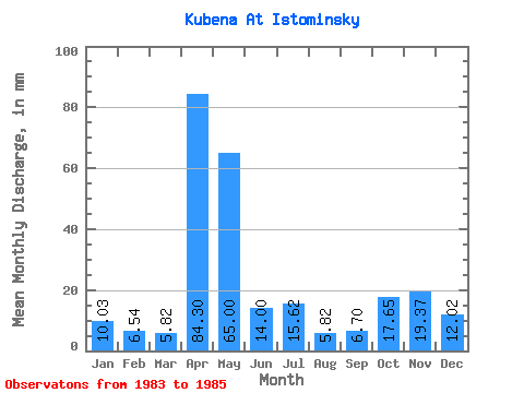
| Units: | m3/s |
| Statistic | Jan | Feb | Mar | Apr | May | Jun | Jul | Aug | Sep | Oct | Nov | Dec | Annual |
|---|---|---|---|---|---|---|---|---|---|---|---|---|---|
| Mean | 10.03 | 6.60 | 5.82 | 84.30 | 64.99 | 14.00 | 15.62 | 5.82 | 6.71 | 17.65 | 19.37 | 12.02 | 262.88 |
| Standard Deviation | 5.68 | 2.90 | 1.99 | 61.54 | 26.72 | 8.29 | 15.56 | 1.65 | 3.04 | 10.35 | 8.05 | 9.74 | 41.51 |
| Min | 4.79 | 4.22 | 3.62 | 24.55 | 36.15 | 8.94 | 4.93 | 4.04 | 4.59 | 6.72 | 10.60 | 5.87 | 218.58 |
| Max | 16.07 | 9.83 | 7.47 | 147.49 | 88.91 | 23.56 | 33.48 | 7.31 | 10.19 | 27.32 | 26.44 | 23.25 | 300.87 |
| Coefficient of Variation | 0.57 | 0.44 | 0.34 | 0.73 | 0.41 | 0.59 | 1.00 | 0.28 | 0.45 | 0.59 | 0.42 | 0.81 | 0.16 |
 Return to R-Arctic Net Home Page