|
|
|||||||||||||||||
| Point ID: 8923 | Downloads | Plots | Site Data | Code: 70587 |
|
|
|||||||||||||||||
| Download | |
|---|---|
| Site Descriptor Information | Site Time Series Data |
| Link to all available data | |
| View: | Time Series | All |
| Units: | m3/s |
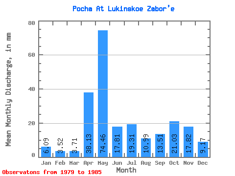
| Statistic | Jan | Feb | Mar | Apr | May | Jun | Jul | Aug | Sep | Oct | Nov | Dec | Annual |
|---|---|---|---|---|---|---|---|---|---|---|---|---|---|
| Mean | 6.09 | 3.55 | 3.71 | 38.13 | 74.45 | 17.81 | 19.30 | 10.98 | 13.51 | 21.03 | 17.82 | 9.17 | 234.65 |
| Standard Deviation | 2.30 | 1.18 | 0.96 | 38.50 | 41.72 | 4.91 | 12.83 | 9.26 | 7.93 | 9.33 | 7.71 | 3.77 | 29.79 |
| Min | 3.26 | 2.03 | 2.62 | 5.36 | 29.70 | 12.91 | 5.43 | 3.66 | 4.16 | 6.03 | 9.85 | 5.14 | 205.74 |
| Max | 8.45 | 5.27 | 5.39 | 109.99 | 150.21 | 23.34 | 40.66 | 25.05 | 25.97 | 32.51 | 29.89 | 16.40 | 272.22 |
| Coefficient of Variation | 0.38 | 0.33 | 0.26 | 1.01 | 0.56 | 0.28 | 0.67 | 0.84 | 0.59 | 0.44 | 0.43 | 0.41 | 0.13 |
 Return to R-Arctic Net Home Page