|
|
|||||||||||||||||
| Point ID: 8922 | Downloads | Plots | Site Data | Code: 70586 |
|
|
|||||||||||||||||
| Download | |
|---|---|
| Site Descriptor Information | Site Time Series Data |
| Link to all available data | |
| View: | Time Series | All |
| Units: | m3/s |
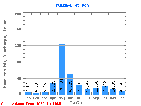
| Statistic | Jan | Feb | Mar | Apr | May | Jun | Jul | Aug | Sep | Oct | Nov | Dec | Annual |
|---|---|---|---|---|---|---|---|---|---|---|---|---|---|
| Mean | 7.12 | 5.02 | 5.45 | 29.23 | 124.19 | 49.25 | 23.01 | 13.96 | 15.68 | 21.13 | 14.05 | 9.09 | 317.35 |
| Standard Deviation | 3.15 | 1.35 | 0.69 | 35.54 | 17.11 | 12.60 | 8.38 | 4.54 | 5.88 | 7.27 | 4.85 | 6.00 | 28.32 |
| Min | 4.09 | 3.30 | 4.13 | 7.14 | 92.56 | 35.20 | 14.24 | 10.05 | 10.19 | 13.01 | 7.55 | 4.56 | 283.62 |
| Max | 11.09 | 6.42 | 6.11 | 99.13 | 140.95 | 64.57 | 33.03 | 22.13 | 26.33 | 34.25 | 20.51 | 21.89 | 350.16 |
| Coefficient of Variation | 0.44 | 0.27 | 0.13 | 1.22 | 0.14 | 0.26 | 0.36 | 0.33 | 0.38 | 0.34 | 0.34 | 0.66 | 0.09 |
 Return to R-Arctic Net Home Page