|
|
|||||||||||||||||
| Point ID: 8900 | Downloads | Plots | Site Data | Code: 70558 |
|
|
|||||||||||||||||
| Download | |
|---|---|
| Site Descriptor Information | Site Time Series Data |
| Link to all available data | |
| View: | Time Series | All |
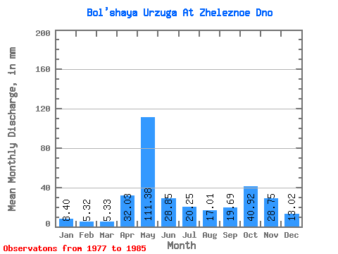
| Units: | m3/s |
| Statistic | Jan | Feb | Mar | Apr | May | Jun | Jul | Aug | Sep | Oct | Nov | Dec | Annual |
|---|---|---|---|---|---|---|---|---|---|---|---|---|---|
| Mean | 8.40 | 5.37 | 5.33 | 32.03 | 111.36 | 28.85 | 20.25 | 17.00 | 19.69 | 40.91 | 28.75 | 13.02 | 360.01 |
| Standard Deviation | 3.35 | 2.20 | 1.84 | 45.49 | 43.29 | 13.53 | 15.75 | 12.04 | 11.39 | 33.49 | 16.28 | 6.56 | 80.41 |
| Min | 5.36 | 3.18 | 2.93 | 4.67 | 36.59 | 12.88 | 7.42 | 3.49 | 4.06 | 4.79 | 4.28 | 5.22 | 265.91 |
| Max | 13.97 | 9.15 | 7.45 | 130.08 | 164.34 | 46.37 | 51.56 | 40.59 | 36.38 | 114.77 | 53.45 | 23.85 | 500.25 |
| Coefficient of Variation | 0.40 | 0.41 | 0.34 | 1.42 | 0.39 | 0.47 | 0.78 | 0.71 | 0.58 | 0.82 | 0.57 | 0.50 | 0.22 |
 Return to R-Arctic Net Home Page