|
|
|||||||||||||||||
| Point ID: 89 | Downloads | Plots | Site Data | Code: 05AD008 |
|
|
|||||||||||||||||
| Download | |
|---|---|
| Site Descriptor Information | Site Time Series Data |
| Link to all available data | |
| View: | Time Series | All |
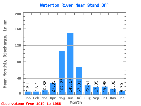
| Units: | m3/s |
| Statistic | Jan | Feb | Mar | Apr | May | Jun | Jul | Aug | Sep | Oct | Nov | Dec | Annual |
|---|---|---|---|---|---|---|---|---|---|---|---|---|---|
| Mean | 7.46 | 7.65 | 10.46 | 27.60 | 105.99 | 147.52 | 67.02 | 22.25 | 17.75 | 19.75 | 14.84 | 9.79 | 486.15 |
| Standard Deviation | 2.31 | 4.58 | 5.09 | 14.52 | 31.78 | 55.11 | 33.77 | 11.92 | 17.52 | 16.07 | 8.57 | 4.33 | 135.01 |
| Min | 3.92 | 3.44 | 2.15 | 8.39 | 27.09 | 43.75 | 25.39 | 9.41 | 6.53 | 5.45 | 4.17 | 4.15 | 266.68 |
| Max | 12.94 | 26.94 | 29.10 | 70.42 | 181.11 | 287.67 | 176.47 | 80.34 | 107.72 | 88.54 | 39.70 | 20.43 | 955.89 |
| Coefficient of Variation | 0.31 | 0.60 | 0.49 | 0.53 | 0.30 | 0.37 | 0.50 | 0.54 | 0.99 | 0.81 | 0.58 | 0.44 | 0.28 |
 Return to R-Arctic Net Home Page