|
|
|||||||||||||||||
| Point ID: 8899 | Downloads | Plots | Site Data | Code: 70557 |
|
|
|||||||||||||||||
| Download | |
|---|---|
| Site Descriptor Information | Site Time Series Data |
| Link to all available data | |
| View: | Time Series | All |
| Units: | m3/s |
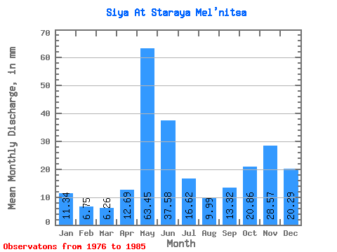
| Statistic | Jan | Feb | Mar | Apr | May | Jun | Jul | Aug | Sep | Oct | Nov | Dec | Annual |
|---|---|---|---|---|---|---|---|---|---|---|---|---|---|
| Mean | 11.34 | 6.80 | 6.26 | 12.69 | 63.44 | 37.58 | 16.62 | 10.00 | 13.32 | 20.85 | 28.57 | 20.29 | 249.20 |
| Standard Deviation | 4.67 | 2.35 | 2.02 | 16.35 | 22.46 | 13.65 | 5.77 | 5.59 | 11.27 | 13.70 | 16.25 | 8.88 | 68.33 |
| Min | 4.97 | 2.89 | 3.81 | 4.10 | 29.64 | 27.76 | 9.84 | 2.33 | 2.05 | 2.65 | 3.59 | 5.08 | 144.49 |
| Max | 18.52 | 10.80 | 9.74 | 55.53 | 91.88 | 69.97 | 26.57 | 17.78 | 37.91 | 39.38 | 52.05 | 32.92 | 359.26 |
| Coefficient of Variation | 0.41 | 0.35 | 0.32 | 1.29 | 0.35 | 0.36 | 0.35 | 0.56 | 0.85 | 0.66 | 0.57 | 0.44 | 0.27 |
 Return to R-Arctic Net Home Page