|
|
|||||||||||||||||
| Point ID: 8890 | Downloads | Plots | Site Data | Code: 70547 |
|
|
|||||||||||||||||
| Download | |
|---|---|
| Site Descriptor Information | Site Time Series Data |
| Link to all available data | |
| View: | Time Series | All |
| Units: | m3/s |
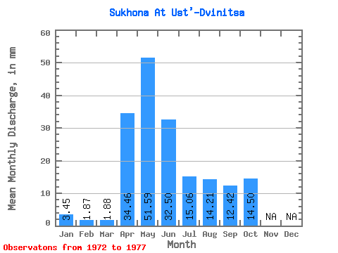
| Statistic | Jan | Feb | Mar | Apr | May | Jun | Jul | Aug | Sep | Oct | Nov | Dec | Annual |
|---|---|---|---|---|---|---|---|---|---|---|---|---|---|
| Mean | 3.45 | 1.89 | 1.88 | 34.46 | 51.59 | 32.50 | 15.06 | 14.21 | 12.42 | 14.50 | |||
| Standard Deviation | 19.69 | 18.69 | 3.01 | 3.22 | 1.96 | 4.05 | |||||||
| Min | 3.45 | 1.89 | 1.88 | 34.46 | 28.01 | 13.71 | 11.39 | 10.36 | 9.87 | 11.39 | |||
| Max | 3.45 | 1.89 | 1.88 | 34.46 | 70.90 | 53.43 | 18.37 | 17.65 | 14.20 | 19.09 | |||
| Coefficient of Variation | 0.38 | 0.57 | 0.20 | 0.23 | 0.16 | 0.28 |
 Return to R-Arctic Net Home Page