|
|
|||||||||||||||||
| Point ID: 8885 | Downloads | Plots | Site Data | Code: 70527 |
|
|
|||||||||||||||||
| Download | |
|---|---|
| Site Descriptor Information | Site Time Series Data |
| Link to all available data | |
| View: | Time Series | All |
| Units: | m3/s |
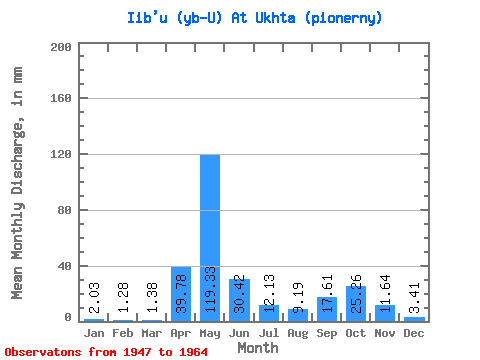
| Statistic | Jan | Feb | Mar | Apr | May | Jun | Jul | Aug | Sep | Oct | Nov | Dec | Annual |
|---|---|---|---|---|---|---|---|---|---|---|---|---|---|
| Mean | 2.02 | 1.30 | 1.38 | 39.78 | 119.32 | 30.41 | 12.14 | 9.20 | 17.62 | 25.27 | 11.64 | 3.41 | 275.76 |
| Standard Deviation | 0.61 | 0.43 | 0.44 | 43.22 | 40.53 | 15.41 | 7.03 | 9.27 | 26.22 | 15.69 | 7.72 | 1.82 | 47.05 |
| Min | 0.95 | 0.67 | 0.71 | 1.47 | 45.85 | 7.07 | 2.44 | 1.32 | 1.30 | 1.89 | 1.24 | 1.20 | 208.83 |
| Max | 3.25 | 2.40 | 2.23 | 127.05 | 200.24 | 58.71 | 23.74 | 39.76 | 113.89 | 62.49 | 30.45 | 7.71 | 401.43 |
| Coefficient of Variation | 0.30 | 0.33 | 0.32 | 1.09 | 0.34 | 0.51 | 0.58 | 1.01 | 1.49 | 0.62 | 0.66 | 0.53 | 0.17 |
 Return to R-Arctic Net Home Page