|
|
|||||||||||||||||
| Point ID: 8877 | Downloads | Plots | Site Data | Code: 70475 |
|
|
|||||||||||||||||
| Download | |
|---|---|
| Site Descriptor Information | Site Time Series Data |
| Link to all available data | |
| View: | Time Series | All |
| Units: | m3/s |
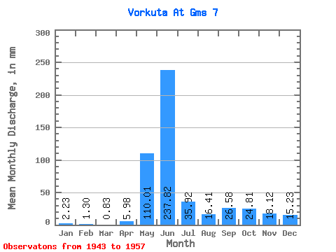
| Statistic | Jan | Feb | Mar | Apr | May | Jun | Jul | Aug | Sep | Oct | Nov | Dec | Annual |
|---|---|---|---|---|---|---|---|---|---|---|---|---|---|
| Mean | 2.23 | 1.31 | 0.83 | 5.98 | 110.00 | 237.82 | 35.92 | 16.41 | 26.58 | 24.80 | 18.12 | 15.23 | 485.35 |
| Standard Deviation | 1.54 | 1.14 | 0.94 | 8.85 | 75.63 | 109.99 | 34.95 | 14.98 | 22.44 | 20.10 | 35.53 | 41.31 | 97.74 |
| Min | 0.57 | 0.19 | 0.10 | 0.65 | 9.03 | 45.31 | 10.45 | 5.04 | 0.31 | 2.71 | 2.42 | 1.37 | 384.32 |
| Max | 5.37 | 3.82 | 3.06 | 28.49 | 206.07 | 407.18 | 115.86 | 59.45 | 70.41 | 58.50 | 140.63 | 158.59 | 716.69 |
| Coefficient of Variation | 0.69 | 0.87 | 1.14 | 1.48 | 0.69 | 0.46 | 0.97 | 0.91 | 0.84 | 0.81 | 1.96 | 2.71 | 0.20 |
 Return to R-Arctic Net Home Page