|
|
|||||||||||||||||
| Point ID: 8873 | Downloads | Plots | Site Data | Code: 70453 |
|
|
|||||||||||||||||
| Download | |
|---|---|
| Site Descriptor Information | Site Time Series Data |
| Link to all available data | |
| View: | Time Series | All |
| Units: | m3/s |
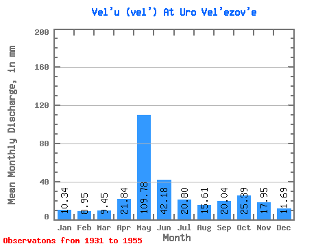
| Statistic | Jan | Feb | Mar | Apr | May | Jun | Jul | Aug | Sep | Oct | Nov | Dec | Annual |
|---|---|---|---|---|---|---|---|---|---|---|---|---|---|
| Mean | 10.34 | 9.03 | 9.45 | 21.84 | 109.76 | 42.18 | 20.80 | 15.61 | 20.04 | 25.39 | 17.95 | 11.69 | 310.73 |
| Standard Deviation | 1.19 | 1.31 | 1.46 | 24.14 | 37.18 | 21.85 | 10.46 | 4.13 | 9.86 | 11.93 | 6.42 | 2.24 | 58.08 |
| Min | 7.98 | 6.61 | 6.67 | 7.46 | 42.34 | 18.05 | 13.43 | 11.93 | 11.98 | 11.58 | 9.67 | 8.08 | 197.87 |
| Max | 13.26 | 11.52 | 12.20 | 95.81 | 189.14 | 115.48 | 51.26 | 26.52 | 50.39 | 67.97 | 33.02 | 16.97 | 405.09 |
| Coefficient of Variation | 0.12 | 0.15 | 0.15 | 1.10 | 0.34 | 0.52 | 0.50 | 0.27 | 0.49 | 0.47 | 0.36 | 0.19 | 0.19 |
 Return to R-Arctic Net Home Page