|
|
|||||||||||||||||
| Point ID: 8872 | Downloads | Plots | Site Data | Code: 70450 |
|
|
|||||||||||||||||
| Download | |
|---|---|
| Site Descriptor Information | Site Time Series Data |
| Link to all available data | |
| View: | Time Series | All |
| Units: | m3/s |
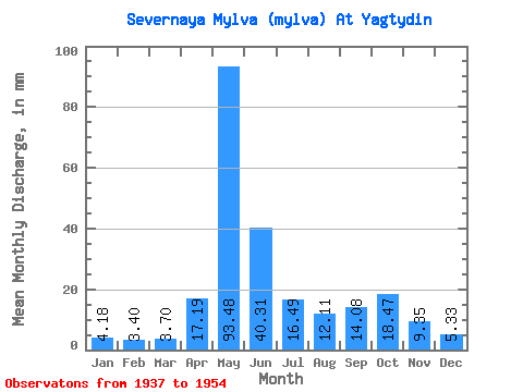
| Statistic | Jan | Feb | Mar | Apr | May | Jun | Jul | Aug | Sep | Oct | Nov | Dec | Annual |
|---|---|---|---|---|---|---|---|---|---|---|---|---|---|
| Mean | 4.18 | 3.43 | 3.70 | 17.18 | 93.47 | 40.31 | 16.49 | 12.11 | 14.08 | 18.47 | 9.35 | 5.32 | 235.10 |
| Standard Deviation | 0.91 | 0.64 | 0.48 | 21.09 | 29.21 | 19.31 | 11.99 | 8.30 | 8.62 | 10.49 | 4.21 | 1.34 | 44.62 |
| Min | 2.77 | 2.26 | 3.02 | 3.19 | 46.39 | 7.46 | 5.98 | 4.67 | 4.85 | 4.32 | 4.20 | 3.49 | 122.42 |
| Max | 5.44 | 4.36 | 4.42 | 67.42 | 134.58 | 81.16 | 48.02 | 28.67 | 32.27 | 38.95 | 18.26 | 8.18 | 308.89 |
| Coefficient of Variation | 0.22 | 0.19 | 0.13 | 1.23 | 0.31 | 0.48 | 0.73 | 0.69 | 0.61 | 0.57 | 0.45 | 0.25 | 0.19 |
 Return to R-Arctic Net Home Page