|
|
|||||||||||||||||
| Point ID: 887 | Downloads | Plots | Site Data | Code: 07FB008 |
|
|
|||||||||||||||||
| Download | |
|---|---|
| Site Descriptor Information | Site Time Series Data |
| Link to all available data | |
| View: | Time Series | All |
| Units: | m3/s |
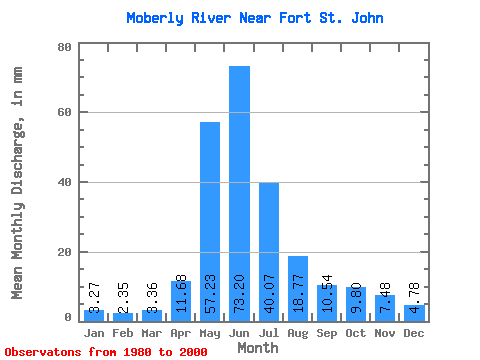
| Statistic | Jan | Feb | Mar | Apr | May | Jun | Jul | Aug | Sep | Oct | Nov | Dec | Annual |
|---|---|---|---|---|---|---|---|---|---|---|---|---|---|
| Mean | 3.27 | 2.37 | 3.35 | 11.68 | 57.23 | 73.20 | 40.06 | 18.77 | 10.54 | 9.80 | 7.48 | 4.78 | 241.76 |
| Standard Deviation | 1.60 | 0.92 | 2.71 | 8.15 | 26.60 | 24.00 | 21.34 | 20.83 | 8.81 | 6.74 | 4.88 | 2.52 | 57.85 |
| Min | 0.85 | 0.75 | 0.88 | 2.63 | 7.95 | 31.89 | 13.50 | 4.44 | 1.05 | 0.95 | 0.70 | 0.72 | 166.91 |
| Max | 6.89 | 4.35 | 14.24 | 29.16 | 121.22 | 141.88 | 99.90 | 97.43 | 34.28 | 23.79 | 19.10 | 9.81 | 382.56 |
| Coefficient of Variation | 0.49 | 0.39 | 0.81 | 0.70 | 0.47 | 0.33 | 0.53 | 1.11 | 0.84 | 0.69 | 0.65 | 0.53 | 0.24 |
 Return to R-Arctic Net Home Page