|
|
|||||||||||||||||
| Point ID: 8865 | Downloads | Plots | Site Data | Code: 70398 |
|
|
|||||||||||||||||
| Download | |
|---|---|
| Site Descriptor Information | Site Time Series Data |
| Link to all available data | |
| View: | Time Series | All |
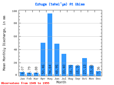
| Units: | m3/s |
| Statistic | Jan | Feb | Mar | Apr | May | Jun | Jul | Aug | Sep | Oct | Nov | Dec | Annual |
|---|---|---|---|---|---|---|---|---|---|---|---|---|---|
| Mean | 6.07 | 4.83 | 4.87 | 50.46 | 94.63 | 48.95 | 33.40 | 16.70 | 15.70 | 27.13 | 15.68 | 7.36 | 319.02 |
| Standard Deviation | 1.00 | 0.73 | 0.64 | 44.98 | 42.44 | 29.57 | 24.06 | 11.13 | 8.10 | 13.01 | 8.57 | 1.28 | 57.67 |
| Min | 4.99 | 3.72 | 3.95 | 4.68 | 36.28 | 24.25 | 11.81 | 7.82 | 8.53 | 14.36 | 9.34 | 6.13 | 252.33 |
| Max | 7.67 | 5.92 | 5.81 | 106.19 | 135.41 | 103.26 | 73.43 | 37.79 | 32.61 | 46.00 | 32.40 | 9.79 | 411.32 |
| Coefficient of Variation | 0.17 | 0.15 | 0.13 | 0.89 | 0.45 | 0.60 | 0.72 | 0.67 | 0.52 | 0.48 | 0.55 | 0.17 | 0.18 |
 Return to R-Arctic Net Home Page