|
|
|||||||||||||||||
| Point ID: 884 | Downloads | Plots | Site Data | Code: 07FB005 |
|
|
|||||||||||||||||
| Download | |
|---|---|
| Site Descriptor Information | Site Time Series Data |
| Link to all available data | |
| View: | Time Series | All |
| Units: | m3/s |
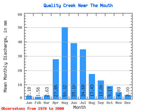
| Statistic | Jan | Feb | Mar | Apr | May | Jun | Jul | Aug | Sep | Oct | Nov | Dec | Annual |
|---|---|---|---|---|---|---|---|---|---|---|---|---|---|
| Mean | 2.19 | 1.55 | 2.60 | 27.87 | 50.14 | 39.09 | 34.69 | 17.45 | 13.02 | 9.20 | 4.82 | 2.95 | 209.32 |
| Standard Deviation | 1.60 | 1.27 | 2.50 | 20.06 | 37.74 | 33.15 | 38.96 | 21.63 | 14.28 | 8.71 | 3.96 | 2.00 | 102.17 |
| Min | 0.00 | 0.08 | 0.09 | 1.41 | 3.36 | 3.60 | 1.36 | 0.55 | 0.00 | 0.55 | 0.26 | 0.09 | 62.32 |
| Max | 4.81 | 5.29 | 10.35 | 67.57 | 129.81 | 129.16 | 151.60 | 82.79 | 58.61 | 30.59 | 15.38 | 6.99 | 449.95 |
| Coefficient of Variation | 0.73 | 0.82 | 0.96 | 0.72 | 0.75 | 0.85 | 1.12 | 1.24 | 1.10 | 0.95 | 0.82 | 0.68 | 0.49 |
 Return to R-Arctic Net Home Page