|
|
|||||||||||||||||
| Point ID: 8838 | Downloads | Plots | Site Data | Code: 70092 |
|
|
|||||||||||||||||
| Download | |
|---|---|
| Site Descriptor Information | Site Time Series Data |
| Link to all available data | |
| View: | Time Series | All |
| Units: | m3/s |
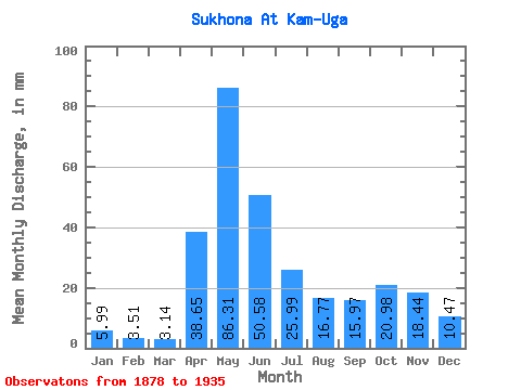
| Statistic | Jan | Feb | Mar | Apr | May | Jun | Jul | Aug | Sep | Oct | Nov | Dec | Annual |
|---|---|---|---|---|---|---|---|---|---|---|---|---|---|
| Mean | 5.99 | 3.54 | 3.14 | 38.65 | 86.30 | 50.58 | 25.98 | 16.77 | 15.97 | 20.98 | 18.44 | 10.46 | 289.32 |
| Standard Deviation | 3.21 | 1.52 | 0.99 | 23.94 | 26.81 | 42.94 | 11.92 | 10.10 | 11.41 | 13.34 | 12.21 | 7.23 | 76.79 |
| Min | 1.56 | 1.14 | 0.85 | 3.00 | 27.61 | 12.39 | 9.27 | 4.67 | 3.66 | 3.92 | 2.54 | 1.87 | 148.06 |
| Max | 16.89 | 8.89 | 5.24 | 106.49 | 151.55 | 350.96 | 63.80 | 56.40 | 48.49 | 54.88 | 54.25 | 29.55 | 496.92 |
| Coefficient of Variation | 0.54 | 0.43 | 0.32 | 0.62 | 0.31 | 0.85 | 0.46 | 0.60 | 0.71 | 0.64 | 0.66 | 0.69 | 0.27 |
 Return to R-Arctic Net Home Page