|
|
|||||||||||||||||
| Point ID: 8834 | Downloads | Plots | Site Data | Code: 70041 |
|
|
|||||||||||||||||
| Download | |
|---|---|
| Site Descriptor Information | Site Time Series Data |
| Link to all available data | |
| View: | Time Series | All |
| Units: | m3/s |
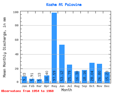
| Statistic | Jan | Feb | Mar | Apr | May | Jun | Jul | Aug | Sep | Oct | Nov | Dec | Annual |
|---|---|---|---|---|---|---|---|---|---|---|---|---|---|
| Mean | 9.03 | 5.96 | 5.13 | 10.40 | 97.58 | 53.12 | 25.79 | 16.30 | 18.16 | 28.03 | 26.80 | 15.23 | 302.51 |
| Standard Deviation | 1.91 | 1.29 | 1.11 | 10.16 | 38.92 | 23.80 | 10.77 | 8.90 | 16.04 | 16.08 | 9.70 | 4.18 | 92.02 |
| Min | 6.55 | 3.90 | 3.54 | 2.92 | 28.50 | 16.38 | 10.59 | 4.14 | 5.65 | 11.22 | 16.81 | 10.31 | 136.80 |
| Max | 12.12 | 8.49 | 8.32 | 41.42 | 156.52 | 85.20 | 52.84 | 36.37 | 57.44 | 59.08 | 46.50 | 23.89 | 448.73 |
| Coefficient of Variation | 0.21 | 0.22 | 0.22 | 0.98 | 0.40 | 0.45 | 0.42 | 0.55 | 0.88 | 0.57 | 0.36 | 0.27 | 0.30 |
 Return to R-Arctic Net Home Page