|
|
|||||||||||||||||
| Point ID: 8830 | Downloads | Plots | Site Data | Code: 70035 |
|
|
|||||||||||||||||
| Download | |
|---|---|
| Site Descriptor Information | Site Time Series Data |
| Link to all available data | |
| View: | Time Series | All |
| Units: | m3/s |
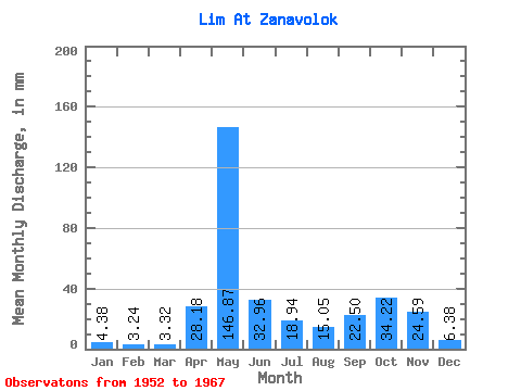
| Statistic | Jan | Feb | Mar | Apr | May | Jun | Jul | Aug | Sep | Oct | Nov | Dec | Annual |
|---|---|---|---|---|---|---|---|---|---|---|---|---|---|
| Mean | 4.38 | 3.27 | 3.32 | 28.18 | 146.85 | 32.96 | 18.94 | 15.05 | 22.50 | 34.21 | 24.59 | 6.38 | 339.29 |
| Standard Deviation | 1.23 | 0.77 | 0.83 | 31.70 | 54.19 | 14.52 | 12.16 | 19.68 | 19.02 | 20.71 | 22.15 | 2.22 | 79.90 |
| Min | 2.17 | 1.88 | 1.91 | 3.15 | 58.82 | 11.29 | 4.95 | 2.27 | 4.29 | 11.97 | 3.40 | 2.32 | 203.77 |
| Max | 6.97 | 4.79 | 4.75 | 109.37 | 238.39 | 62.43 | 51.39 | 62.44 | 73.91 | 96.49 | 95.39 | 10.73 | 484.35 |
| Coefficient of Variation | 0.28 | 0.23 | 0.25 | 1.12 | 0.37 | 0.44 | 0.64 | 1.31 | 0.85 | 0.60 | 0.90 | 0.35 | 0.23 |
 Return to R-Arctic Net Home Page