|
|
|||||||||||||||||
| Point ID: 8821 | Downloads | Plots | Site Data | Code: 12394 |
|
|
|||||||||||||||||
| Download | |
|---|---|
| Site Descriptor Information | Site Time Series Data |
| Link to all available data | |
| View: | Time Series | All |
| Units: | m3/s |
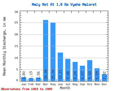
| Statistic | Jan | Feb | Mar | Apr | May | Jun | Jul | Aug | Sep | Oct | Nov | Dec | Annual |
|---|---|---|---|---|---|---|---|---|---|---|---|---|---|
| Mean | 1.79 | 1.20 | 1.56 | 26.07 | 25.04 | 12.21 | 9.49 | 8.23 | 6.56 | 9.03 | 5.59 | 2.92 | 109.50 |
| Standard Deviation | 1.01 | 0.63 | 0.97 | 18.22 | 17.85 | 6.74 | 9.72 | 9.51 | 7.13 | 10.04 | 5.64 | 1.94 | 51.61 |
| Min | 0.46 | 0.40 | 0.44 | 2.84 | 2.38 | 2.31 | 0.73 | 1.02 | 0.83 | 0.92 | 0.69 | 0.59 | 20.84 |
| Max | 4.22 | 2.67 | 4.22 | 68.88 | 75.57 | 23.08 | 37.07 | 44.39 | 27.34 | 41.09 | 22.72 | 7.70 | 201.34 |
| Coefficient of Variation | 0.56 | 0.53 | 0.63 | 0.70 | 0.71 | 0.55 | 1.02 | 1.16 | 1.09 | 1.11 | 1.01 | 0.66 | 0.47 |
 Return to R-Arctic Net Home Page