|
|
|||||||||||||||||
| Point ID: 8810 | Downloads | Plots | Site Data | Code: 12308 |
|
|
|||||||||||||||||
| Download | |
|---|---|
| Site Descriptor Information | Site Time Series Data |
| Link to all available data | |
| View: | Time Series | All |
| Units: | m3/s |
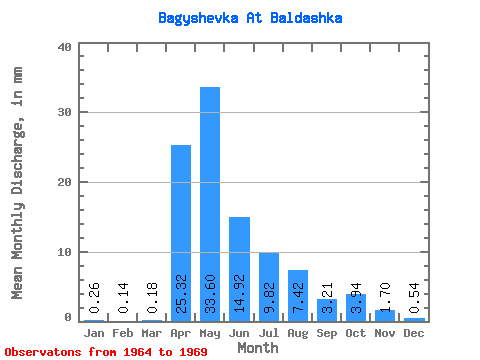
| Statistic | Jan | Feb | Mar | Apr | May | Jun | Jul | Aug | Sep | Oct | Nov | Dec | Annual |
|---|---|---|---|---|---|---|---|---|---|---|---|---|---|
| Mean | 0.26 | 0.14 | 0.18 | 25.33 | 33.60 | 14.91 | 9.82 | 7.42 | 3.21 | 3.95 | 1.71 | 0.53 | 92.19 |
| Standard Deviation | 0.37 | 0.24 | 0.31 | 20.31 | 21.13 | 7.04 | 15.17 | 11.82 | 3.27 | 2.81 | 0.82 | 0.41 | 45.51 |
| Min | 0.00 | 0.00 | 0.00 | 8.42 | 5.16 | 7.13 | 1.34 | 0.60 | 0.44 | 0.51 | 0.37 | 0.07 | 38.21 |
| Max | 0.94 | 0.61 | 0.80 | 64.02 | 65.61 | 27.54 | 40.51 | 31.20 | 9.53 | 7.43 | 2.40 | 1.07 | 149.44 |
| Coefficient of Variation | 1.43 | 1.72 | 1.72 | 0.80 | 0.63 | 0.47 | 1.54 | 1.59 | 1.02 | 0.71 | 0.48 | 0.78 | 0.49 |
 Return to R-Arctic Net Home Page