|
|
|||||||||||||||||
| Point ID: 8805 | Downloads | Plots | Site Data | Code: 12285 |
|
|
|||||||||||||||||
| Download | |
|---|---|
| Site Descriptor Information | Site Time Series Data |
| Link to all available data | |
| View: | Time Series | All |
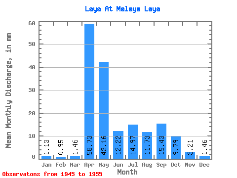
| Units: | m3/s |
| Statistic | Jan | Feb | Mar | Apr | May | Jun | Jul | Aug | Sep | Oct | Nov | Dec | Annual |
|---|---|---|---|---|---|---|---|---|---|---|---|---|---|
| Mean | 1.10 | 0.98 | 1.44 | 58.74 | 42.15 | 12.24 | 14.94 | 11.76 | 15.46 | 9.78 | 3.23 | 1.48 | 180.02 |
| Standard Deviation | 0.56 | 0.52 | 1.16 | 46.89 | 23.18 | 9.43 | 28.00 | 17.98 | 25.27 | 10.33 | 2.56 | 0.84 | 115.73 |
| Min | 0.45 | 0.37 | 0.41 | 14.88 | 15.37 | 4.54 | 1.54 | 1.13 | 2.35 | 2.51 | 1.10 | 0.48 | 62.69 |
| Max | 2.10 | 1.84 | 4.29 | 148.05 | 86.57 | 33.67 | 93.12 | 60.68 | 83.01 | 31.55 | 7.83 | 3.40 | 440.03 |
| Coefficient of Variation | 0.51 | 0.53 | 0.80 | 0.80 | 0.55 | 0.77 | 1.88 | 1.53 | 1.64 | 1.06 | 0.79 | 0.57 | 0.64 |
 Return to R-Arctic Net Home Page